

Botherum Hut was built by the Willis family in 1962 on a lease they ran sheep on over the period 1927-66. It was reputedly the last stockmen’s hut to be built prior to the termination of grazing in the Snowy Mountains and is the most simplistic form of stockmen’s hut remaining in the Kosciuszko National Park today.
Snowy and Botherum Plains were part of the Kalkite squatting run throughout the mid-19th century, and may have been grazed as early as the late 1830s. In 1885, brothers Andrew Jackson and James Cunningham of Lanyon and Tuggeranong in the ACT had taken over the run and built a set of yards on the east bank of the Gungarlin 1.5km north of Botherum Hut.
By the First World War, these plains had been heavily selected for freehold and grazing lease. Leslie Wallace purchased a lease over the area on which the hut now sits, and this was sold to Charlie Williamson in 1921 and then Thomas Willis in 1927.
The Willis family ran 1200-1500 sheep on the lease each summer, droving them up from their homestead south of Jindabyne via Kalkite Gap. They did not stay with the sheep all summer but travelled to and from the lease, monitoring the sheep and maintaining the lease, usually camping out a few nights each time or else staying in Davey’s Hut during wet weather. Botherum Hut was built late in their ownership of the lease, by which time the end of grazing was a distinct probability so they kept the deign very simple and low-cost, not bothering with even a fireplace or window.
Botherum Hut – Historical Background – DScott 2018
Graziers were running stock in the valley of the Gungahlin River by the mid-19th century. The lower Gungarlin including Snowy and Botherum (or Botheram) Plains were part of the Kalkite Run, which had been established on the west bank of the Eucumbene River by Robert Moore and William Neale as early as 1838-40. Subsequent holders of the run included Stewart Wallace and Donald Ryrie, who both selected freehold lots between Nimmo Hill and Snowy Plain during the 1870s. Ryrie built a homestead named ‘the Chalet’ on the hillside east of the Gungarlin. Stock were brought up from the homestead on the Eucumbene River through Kalkite Gap at the southeast end of Botherum Plain.
In 1885, brothers Andrew Jackson and James Cunningham of Lanyon and Tuggeranong (now historic estates in Canberra) acquired the Kalkite run. They took over the Ryrie freehold and selected further freehold lots on the west side of the Gungarlin at Snowy Plain and east side at Botherum Plain. On Lot 9 they built a set of yards by the river. Maurice Napthali, Robert Jardine and Robert Geddings also made selections at Snowy Plain during the 1880s, followed by Thomas Bolton, C Bolton and Henry Hedger in the 1900s.
In 1893 the squatting run system was terminated and replaced by various leaseholds. The Cunninghams acquired an improvement lease (#454) over 18000 acres along the east side of the Gungarlin, extending from Nimmo Hill to the Snowy River. This area was subsequently leased by John Liston and Roy Sturgeon from 1919, transferring to TC O’Mara in 1927. In 1934 it was split up into smaller leases, ST Jamieson taking up the northeast part of the plain and area towards Nimmo Hill and Fred Wallace taking up the southern part of the plain and area to the Snowy River. Post-WW2, the Jamieson family with RC Collman retained snow leases over the Jamieson’s former area; Fred Wallace’s lease area was taken up by Woodhouse & Girvan in 1943 and then David Williamson in 1950.
By the First World War, the west bank of the Gungarlin River through Snowy and Botherum Plains had been entirely selected as freehold or conditional lease. Leslie Wallace took up the last lots (30, 31, 39) of 2176 acres at Botherum Plain in 1914 as a conditional lease (CL14.25).
Charles Williamson took over Leslie Wallace’s lease in 1919 and in 1921 took over the conditional leases for Henry Hedgers Lot 29 and C Bolton’s Lot 23, bringing his total acreage along the west bank of the River to 2776 acres. In 1927 Williamson sold his lease over lot 39 of 1644 acres to Thomas Henry Willis of Glenrock south of Jindabyne. The Willis family retained this lot through to its resumption for public recreation in 1966; through ownership transfer to Thomas’ sons Lindsay and Ashley Willis in 1942; and in 1946 Ashley's share was sold to his younger brother Jack Willis.
The Willis family first ran sheep on the lease in the summer of 1927-28. For the next 30 years they would run 1200 to 1500 sheep on the plain each summer, not staying throughout the season but making periodic visits to move the sheep onto the lease, muster them for the autumn withdrawal, to treat them for disease, and generally check on animal health and fences.
Jack Willis’ son Henry travelled up with the sheep from 1950 on “We’d get the sheep ready before Christmas; dipped and drenched, take them to the reserve at Jindabyne in the afternoon, packed up and ready to go at daylight. Sheep that had been up here before, [well] when the gate was opened by the hell they’d go! They’d knock themselves up if you didn’t have a bloke and a good dog to hold them. We’d go from Jindabyne to the mill flat for lunch up Kalkite Creek. We’d leave [there] around 3 o’clock; when they were ready to move they’d start getting restless; then we’d pack up and go again. At first we would yard them in the old yards, then later the new yards.”
Their route took them up the west bank of the Snowy and Eucumbene ( now under Lake Jindabyne) toward Kalkite Station, then up Kalkite Creek past the old sawmill, across the plain past Fred Wallace’s Hut and over the Gungarlin on a narrow timber stockbridge. During the snowmelt period in Spring the river was too deep and swift to get the sheep across; the bridge was essential. It had probably been built by the Lands Dept in the early 1900s; the Willis’s undertook maintenance on it to keep it trafficable and Henry recalled “when the sheep got a good tail up you could see the bridge moving up and down” as they crossed over.
“We’d put the horses in Davey (Williamson’s) redbank paddock. They’d be wanting to go home so they’d be hanging round the gate there, so we didn’t have far to go to get our horses in the morning. There were no wild horses here then and very few ‘roos. Dad always claimed he shot the last brumby on Snowy Plains; she’d lead our horses away, so he shot her.
“Another time I wasn’t here,, dad often told about. They were drafting sheep and one of them got staked on a stick that ripped him along the bottom of the gut. The gut started to fall out so they sewed him up with a piece of wire. He lived but they had to get the wire out before they started shearing. It is surprising what a sheep will put up with.”
The Willis’s generally camped a few nights on the lease each time, or stayed at Davey’s Hut during foul weather. Their camp was on the site of the current hut, a clear area elevated above the river to avoid the worst frosts and shielded from the west by a ridge.
At other times the Willis’s worked their home stations or on other leases. In 1928 Jack Willis discovered the body of missing skier Evan Hayes whilst tending sheep on Mt Kosciuszko. In 1930 Lindsay Willis worked with Herb Mawson to build Mawson's Hut.
An old set of timber sheepyards was situated on the riverbank downhill of the hut. Of drop-log construction, they were old by the time the Willis’ took up the lease in 1927, and little evidence remains. They were maintained and used by drovers moving sheep on and off snow leases further up the Gungarlin.
Around the late 1950s, the Willis’s employed Jack Harvey to construct a new set of yards on a spur overlooking the bend in the river south of the current hut. He used a Massey tractor to drag timber for the posts down from the woodland above. Although strongly-built, Henry Willis recalled the yards were not a good design; the drafting run was too wide and made sheep difficult to handle. Jack’s brother Mervyn was also employed for a few years – “Like Jack, not a fancy bone in his body, but he’d just go and wouldn’t stop.”
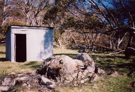
Botherum Hut was built in the spring of 1962 by Lindsay Willis and his son Owen, Jack Willis son Henry paid for half the materials. Posts for the frame were cut from the forest on the hill behind the hut. Corrugated iron was nailed over the frame to create a basic weatherproof box, with an earth floor and opening wall panel in lieu of a window. Furniture was limited to a table, some stools and two camp stretchers. Cooking was done outside when fine, on a small fireplace opposite the door, and inside over a 44-gallon drum with the door and shutter open if the weather was foul. Henry recalled “we kept it simple because we could see the writing on the wall” referring to the decline of grazing.
In 1958 all grazing had been terminated above 1370m (4500’), and through the 1960s there were increasing rumours about it being stopped throughout the mountains to protect water catchments of the Snowy Scheme dams and environmental values. In 1966 the Willis lease was withdrawn and the area gazetted for public recreation, subsequently being incorporated in the Kosciuszko National Park.
Documentary Sources
Cserhalmi & Partners (Rice): Botherum Hut Heritage Action Statement for NPWS 2009
Hueneke, K: Boobee Hut - KHA Information Sheet #6, c1977; Huts of the High Country, ANU Press 1982; People of the Australian High Country, Tabletop Press 1994.
KHA records, database and images.
NSW Dept of Land and Property Information: parish maps c1880s-1970 (Gungarlin & Kalkite), snow lease plans 1943-68.
Willis, Henry: interview recorded by Graham Scully in notes ‘Huts, Sites and Stories around the Gungarlin and Botheram Plain’ 2006.
Willis, Henry: historical notes on KHA file undated.
Some Nearby Points of Interest
The sheepbridge site 800m southeast of hut, mostly gone but defined by logs sticking up in the river (2006).
The two stockyard sites; old yard 500m east of hut; new yard 1.2km south; some timber post and rails remain at each.
Further afield are the sites of Tom Jamieson’s hut and yards on the northern edge of Botherum Plain, and Fred Wallace’s Hut on the south.
Snowy Scheme sites in the area include the Gungahlin Aqueduct Intake Weir and gauging station site, on the river ~1km downstream of the Plain, and a camp location 900m southeast of hut (possibly no evidence).
Amenity
Water – in small creek ~80m to the north. Low flow may be problematic in hot/dry conditions; Gungarlin River available 300m to east.
Toileting – no outhouse.
Firewood – plentiful along treeline to northwest and southeast
Nearest Phone Reception Point in an Emergency – (??)
Nearest Trackhead/Public Road – Gungarlin Powerline Road, very infrequent traffic below Nimmo Hill turnoff to upper Gungarlin