

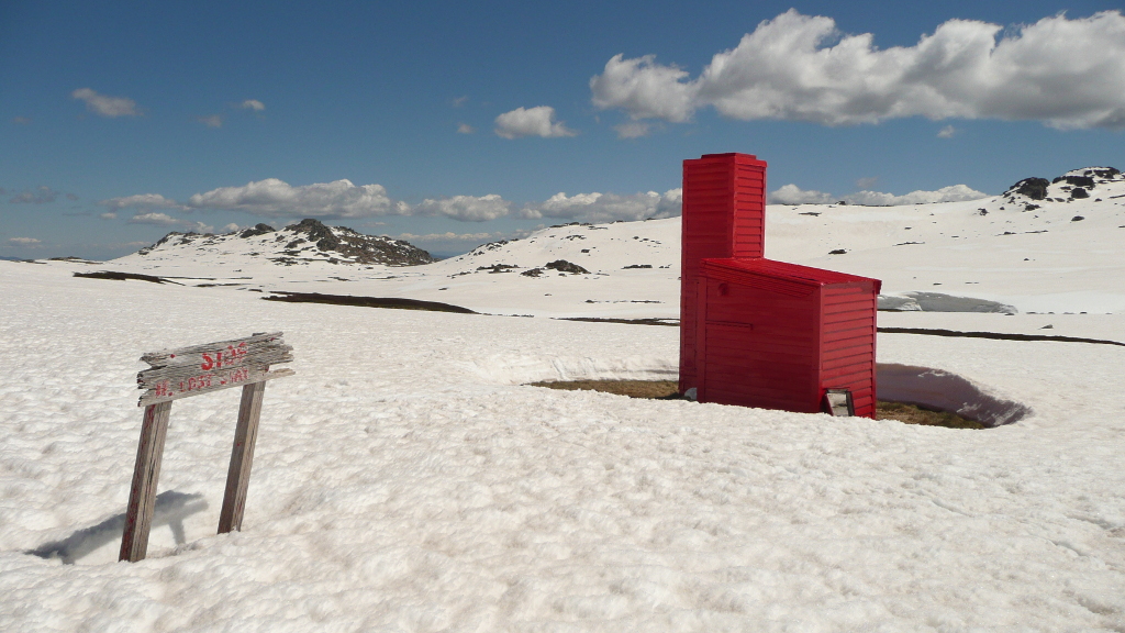
Cootapatamba Hut was constructed by the Snowy Mountains Authority c1952 as an emergency shelter for hydrologists monitoring stations on Cootapatamba Creek — which in the early stages of the Snowy Mountains Scheme was proposed to be diverted through aqueducts and tunnels to supply a ‘Kosciusko Reservoir’ on Spencers Creek near The Chalet.
Detailed hydrological survey of the summit area commenced around 1950 to assist in planning the proposed Kosciusko Reservoir.
Rawsons Hut was built beside the Snowy River northeast of Seamans Hut as a base for hydrologists and surveyors. Numerous monitoring stations were erected across the summit area including a stream gauging station on Cootapatamba Creek downstream of the hut and a monitoring station on the Lake itself.
At the time it was proposed to divert Cootapatamba Creek into an aqueduct around Mt Kosciuszko, through a tunnel to near Seamans Hut and then via another aqueduct over Charlottes Pass to Spencers Creek.
Dick vander Vliet and hydrologist Arne Kirkemo worked on the construction of Cootapatamba Hut. Snow poles were erected around the periphery to assist finding it during deep snow.
The hydrologists were required to monitor the various stations and take other measurements through the winter months, travelling on skis to each location. Cootapatamba served as an emergency shelter less the hydrologists be caught out in a blizzard such as caught Seaman and Hayes in 1928, Hayes body being found ~1km north of the hut.
The aqueduct and tunnel proposal was abandoned c1965. The gauging stations were all removed from the summit area but Cootapatamba Hut was left in place as an emergency shelter.
Cootapatamba Hut – Historical Background – DScott 2018
Very little has been recorded about the history of Cootapatamba Hut. Aside from the involvement of Dick vander Vliet and Arne Kirkemo, much of the history is based on analysis of contextual SMA operations and developments.
SMA maps show that a wide number of monitoring stations were established across the summit area prior to 1953 including stream gauging stations on Club Lake Creek, the exit from Lake Albina, Wilkinson’s Creek and Cootapatamba Creek. Other monitoring stations were installed on Lake Albina and Lake Cootapatamba, A major weather station was installed at Spencers Creek (still the highest site in the mountains from which weather data is captured), with possibly smaller stations elsewhere including Rawsons Hut and a structure just below the summit of Mt Townsend.
Rawsons Hut was constructed around 1951-52 as a base for survey and hydrological work associated with the proposed aqueduct and tunnel to collect and divert the waters of Cootapatamba and Wilkinsons Creeks. An aqueduct was to run from Cootapatamba Creek ~3km downstream of the Lake around the west side of Mt Kosciuszko to Wilkinsons Creek, where there would be a tunnel intake that took the water under the ridge between Mt Kosciuszko and Muellers Peak ~4km to discharge east of Seamans Hut, where it was to go via another aqueduct over Charlottes Pass into the Kosciusko Reservoir.
The hydrologists were expected to capture measurements from the various monitoring stations, weather data and snow samples throughout the winter months. At this stage of the project, oversnow vehicles were uncommon and it is likely the hydrologists based themselves at Rawsons Hut for a few days at a time and then skied to the various sites across the summit area.
The Cootapatamba Creek gauging station was about 2.5km below the Lake, 4.5-5km from the nearest shelter at Rawsons or Seamans. The loss of Seaman and Hayes in 1928 was a reminder as to how quickly a storm can come in from the northwest and trap the unwary, particularly where the bulk of Mt Kosciuszko obscures the view to the northwest from the Cootapatamba valley. Hayes body had been found not far from the current hut toward the Lake. So the decision was taken to install an emergency shelter in the Cootapatamba valley to safeguard SMA staff operating in that area.
SMA worker Dick vander Vliet and hydrologist Arne Kirkemo are both credited with working on the hut’s construction. Dick recalls “specialised construction features that were used in the construction of the hut”, presumably structural methods used to resist the expected snow and wind loadings. Materials were likely brought in on horseback or via 4WD truck. Snow poles were erected around the periphery to assist finding it during deep snow.
Arne was a keen skier and undertook hydrological survey work in the summit area and Valentine/Geehi area, overseeing the construction of the current Valentine Hut in 1955.
There are no records of the hut being used by the SMA, and few related to its subsequent recreational use — due to it being away from the main travel routes in the summit area.
The Kosciusko Reservoir proposal including the Cootapatamba/Wilkinsons aqueduct and tunnel was abandoned c1965. SMA maps indicate all of the gauging stations within the summit area had been removed of decommissioned by 1969. The hut appears to have been left in place as an emergency shelter, being the only shelter on the range west of Mt Kosciuszko and considering chairlifts had just been built to provide access up onto the range from the Thredbo Valley.
Documentary Sources
Ashley, G: ‘NPWS Huts Study’ unpublished report by NPWS 1992 (reference to Dick vander Vliet – probably from interview on file)
Hueneke, K: Huts of the High Country, ANU Press 1982, p13-15.
Hueneke, K: People of the High Country, Tabletop Press 1994, p353.
KHA file records & Cootapatamba Hut Information Sheet #10.
SMA 1” to Mile series maps, Geehi sheets 1962, 1964, 1969.
Some Nearby Points of Interest
Site of stream gauging station ~1.2km downstream on Cootapatamba Ck GPS coordinates WGS84 55 611670E 5961810S (location+/- 200m, uncertain if anything remains)
Site Evan Hayes body was found ~1km north on the side of Mt Kosciuszko GPS coordinates WGS84 55 612959E 5963362S (no remnant evidence just a location)
Amenity
Water – abundant in Cootapatamba Creek during any conditions.
Toileting – nil.
No fireplace; no firewood in vicinity for outside fire.
Camping – reasonable flat sites around the hut but highly exposed to prevailing winds.
Nearest Phone Reception Point in an Emergency – (??)
Nearest Trackhead/Public Road – Thredbo Express Chairlift Top Station 4km (2km off trail; 2km along the Kosciuszko walkway)