

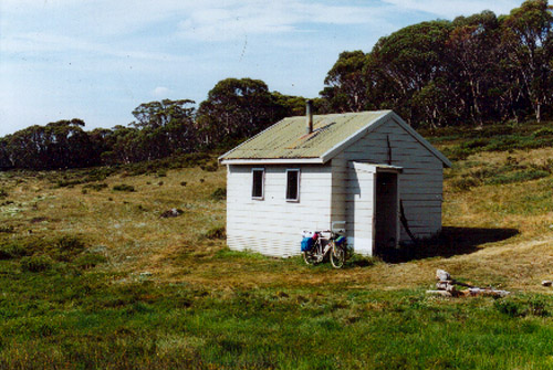
Derschkos Hut was constructed by the Snowy Mountains Authority c1960 as an emergency shelter for hydrologists monitoring precipitation, snow depths and stream flows across the headwaters of the Tumut and Tooma Rivers after two men became trapped in an oversnow vehicle for 3 days during a blizzard.
Hydrological survey of the major watersheds surrounding Mt Jagungal commenced in 1950 in preparation for the Upper Tumut Group projects including the Tumut Pond, Happy Jacks and Tooma Reservoirs.
From project design through to present day operations, hydrologists have been recording precipitation and stream flows on the upper Tumut and Tooma Rivers to ascertain the amount of water available for power generation at the Tumut 1 & 2 power stations. From the late 1950s to 1970s, tracked oversnow vehicles were used to travel out to the headwaters and obtain readings during the winter months.
On one such trip, the vehicle of Czech hydrologist George Derschko and an SMA colleague became incapacitated. The men were trapped in the vehicle for 3 days by a blizzard; lucky to survive. As a consequence, the existing hut was built to ensure the safety of SMA staff working in the area and serve as a base for survey works.
The hut was left unlocked for the safety of recreational park users. Ownership of the hut transferred to NPWS in 1991; the SMA using a containerised hut on the Hellhole Ck Trail for several years before evolving technology allowed many aspects of previous field survey to be automated or undertaken remotely.
Derschkos Hut – Background
The Upper Tumut Group of projects including Tumut Pond, Happy Jacks and Tooma Reservoirs with their aqueducts and interconnecting tunnels, plus the Tumut 1 & 2 Power Stations and Switching Centre, was constructed 1952-62 — the first major group of hydro-electric projects to be constructed within the Snowy Mountains Scheme, following on from the small power station at Guthega.
Whilst hydrological survey was a critical aspect in planning for the Scheme, compiling detailed records of weather and precipitation, and comparing these against stream flows and other factors such as evaporation or changes to surface runoff due to the discontinuation of grazing or bushfire events, was required to refine the Scheme as construction progressed and assist with ongoing power management to the present day.
Through the 1950s to 70s, a range of measuring apparatus — ‘hydrometric stations’ — was installed across the upper catchments of the Tumut, Tooma and Geehi Rivers surrounding Mt Jagungal. Some were still evident in recent years including Stevenson screen-type weather stations (examples near Bogong Ck & Duck Creeks), snow depth gauges (rows of 5 black & white banded poles ~5m high beside the Tooma at the Grey Mare Trail crossing, single poles with a stacked Z batten arrangement in the saddle above Straight Ck and the saddle above Duck Ck), concrete weirs to measure flow volume (Straight Ck between Grey Mare & Valentine Falls), flying foxes with devices to measure flow rates (Geehi River upstream of Straight Ck junction – long gone). Measurements were required on a regular (monthly?) basis, and most required staff to travel out to each site by four wheel drive or oversnow vehicle.
Many of the early hydrologists came from European alpine countries and were well suited to this type of work. Tom Frece, a hydrologist and member of the Thredbo Ski Patrol, remembers the SMA Hydrology Branch comprised many former Olympic and active racing skiers during the mid-1950s and early 1960s.
The hut is named after one such hydrologist and skier, George Derschko, a Czechoslovakian migrant who became one of the earliest hydrologists on the Scheme. During the 1950s he was a senior hydrologist based in Cabramurra and in charge of Upper Tumut hydrometric stations, of which there were many located in the vicinity of the current Hut. In the 1950s he was a member of the Kiandra Pioneers Ski Club and obtained a 3rd placing in the National Downhill championships in 1960. During the 1960s he appears to have moved to Thredbo, joining the Australian Alpine Club and Thredbo Ski Patrol, and by 1970 was also a member of the Kosciusko Alpine Club.
A latter hydrologist strongly connected with the hut is Frank Gyorgy who used the hut during the 1970s and 80s, both for hydrological work, as a winter base for cross-country skiing and in summer as a base camp for walks. In the 1980s, Frank Gyorgy went on a number of cross-country skiing trips with Tom Frece during which they spent some nights based at Derschkos.
The exact date of the hut’s construction is unclear but sometime between 1958 and 1965 appears likely.
Derschkos Hut was originally clad in timber weatherboards — painted bright orange with two black stripes on the roof. It had a common room with a stove and bench as per present arrangement. Separate quarters were provided for a hydrologist and assistant – each with a single bed and large steel trunk to store equipment and stores. A small storage shed was located uphill to the southeast.
By the mid 1980s increasing recreational use of the hut had led to some conflicts between SMA staff and ski tourers, which led to the SMHEA deciding to install a locked shipping container fitted out as a hut on the Hellhole Ck Trail a short distance away. The intention was to remove the container each summer, but this rarely happened up to its permanent removal in the late 1990s.
Upon handover to NPWS the exterior of Derschkos hut was re-clad in Hardie-plank fibre cement weatherboards, the timber sash windows were replaced with aluminium double-glazed units, and the whole colour scheme was changed from bright orange to muted green/beige tones.
Derschkos Hut is culturally significant one of few surviving huts associated with the Snowy Mountain Scheme, and its proximity to Mt Jagungal and the Australian Alps Walking Track makes it of high recreational and shelter value.
References
Hueneke, K: Huts of the High Country, ANU Press 1982, p43-44.
KHA records: Ron De Marco (SMA surveyor) notes from interview, undated; Grahan Scully pers comm, David Scott pers comm.
Lamble, T: Jagungal & The Brassy Mountains ski touring map Ed3 1983.
Derschko, George: Kiandra as I saw It, ASYB 1957; p63-64.
Anton, C: Ski Tourers Association Report, ASYB1961, p122
Australian Alpine Club website http://www.australianalpineclub.com/heritage/80-part-8-1-the-alps-at-the-crossroads-and-the-growth-of-the-aac-after-1962.html
Ward, GRT: Diamond Jubilee of the Kosciusko Alpine Club, KAC 1970.
Friends of Thredbo Newsletter: Kiandra Invitation Ski Races – July 1961 article, Issue #48 June 2011, p5 http://www.kiamaalpineclub.org.au/kac-articles/newsletters/ths-thredbo-museum-flyers/ths-thredbo-museum-flyer-201106.pdf
Some Nearby Points of Interest
The area surrounding Derschkos Hut consists of sub-alpine woodlands, grassed plains, Bossiaea foliosa heath and a Sphagnum bog immediately to the west of the hut which is considered to be a habitat for the critically endangered Southern Corroboree frog Pseudophryne corroboree. However numbers of the species have been in decline in known sites across the extent of its habitat. In particular an extensive study undertaken between 1996 and 1998 found that species had disappeared from many known habitats, such as the sphagnum bog near Derschkos.
Amenity
Water – in small creek 50m to west. Low flow may be problematic in hot/dry conditions.
Toileting – pit toilet.
Firewood – modest availability along ridge to south.
Camping – sloping ground around hut unsuited but numerous excellent sites amidst snowgums on ridge above hut ~100m east.
Emergency Information
Nearest Phone Reception Point in an Emergency – (??)
Nearest Trackhead/Public Road – Round Mt trailhead 15km to north on Cabramurra-Khancoban Rd, infrequent traffic and road closed in winter.